Flookersbrook
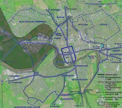
Chester's ancient boundaries are defined to north of the River Dee by the stream which is in part known as "Flookersbrook" and empties into the River Dee after a long and winding journey around the city. In the 10th and 11th centuries Chester hundred was one of twelve in Cheshire, but the creation of civic institutions in the 12th and 13th centuries led to the disappearance of the hundred and its replacement by the liberties of the city, the area within which the citizens enjoyed their various individual and corporate privileges. The liberties were first explicitly demarcated by a precise boundary in 1354 but must have existed long previously as a territory whose limits were generally known. They covered some 3,000 acres and included the abbot of Chester's manor north of the city, and an extensive area south of the Dee, focused on Handbridge. Both the manor of Handbridge and its open fields extended beyond the liberties into the township of Claverton to the south and the actual boundary was marked by the "Great Ditch" which met the river at Heronbridge.
On the north-east, north, and north-west the townships immediately beyond the liberties were Great Boughton, Hoole, Newton, Bache, and Blacon. The Hoole boundary was little more than ½ mile from the heart of Chester at the Cross (the central crossroads by St Peter's church, also the site of the medieval High Cross). The approach to Great Boughton, 1½ miles distant from the Cross, lay through Chester's most important medieval and early modern suburb in Foregate Street and its continuation beyond the Bars, which was called Boughton. Right on the boundary from the early 12th century until the 1640s stood the leper hospital of St. Giles, occupying a tiny extra-parochial area called Spital Boughton.
On the south-western side the boundary of the liberties coincided with the national boundary between England and Wales from 1536, when the Act of Union placed the lordship and parish of Hawarden in the newly created Welsh county of Denbighshire (it was transferred to Flintshire in 1541). Curiously, two potential "extramural" archaological sites, "The Cop" on the River Dee and Heronbridge itself lie right on the ancient city boundary.
Flookersbrook, for a small stream, is well represented by historical writers. Daniel Lysons in his "Magna Brittanica" (1810) writes of it:
- "Flookersbrook rises near Chester and running to Bach there joins a stream which in its course from Coughall by Moston and Mollington divides the hundred of Broxton from that of Wirral and falls into the Dee a little below Chester"
St Giles
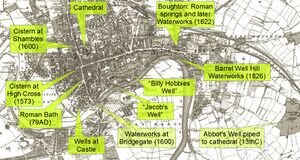
The springs near St Giles Cemetery in Boughton were tapped by the inhabitants of Roman Chester to provide Chester's Water Supply. The water-course from there to Flookersbrook was known as "the Bishop's Ditch". While it is but a short distance to the River Dee from the springs, either the natural topography was such that the run-off from the springs flowed away from the river or the Bishop's Ditch was in part artificial. With the expansion of the waterworks and the construction of the canal and railway no sign of the Bishop's ditch remains today. The boundary of Chester at St Giles was not only the location of the leper hospital but also the place of execution. The location of the natural springs here and the water-course which ran from them did much to shape the growth of the city in ways that are still visible today.
The name 'Boughton' or possibly 'bluestone' may have originated from the placement of a "blue" boundary stone (now lost) alongside the road similar to the Gloverstone which stood outside Chester Castle. St Giles Cemetery and the nearby Gallows Hill are relics of the darker side of Chester history. In 1170 the Earl of Chester Hugh de Kevelioc was reported in the Chester Annals to have built a mound at Boughton out of the heads of Welshmen killed at the 'bridge of Baldert', possibly Balderton (in Dodleston), south of Chester.
Samuel Weston worked on the survey of the Chester Canal (see Canal and Boatyard) in 1769, which failed to get parliamentary sanction. When a new canal scheme was proposed in March 1770, Weston was appointed as surveyor of a canal from Boughton to Middlewich at 10/6 a day (52.5p). That canal would have joined the River Dee near Barrel Well Hill, i.e. above the weir at the Old Dee Bridge and was expected to have cost (according to Weston's estimate) £32,395. A flight of several locks would have been needed to get down to the river and a further lock would probably have to be built at the weir to allow passage at all states of the tide. However narrowboats would be able to sail upriver to Farndon and a possible further canal link to Wrexham.
In September 1770 plans were changed so that the canal would circle around the north of the city and join the Dee at the bend on the New Cut (next to "The Cop"), where a series of sluices drained land recovered by from the Dee Estuary. This plan, which would have effectively followed the course of Flookersbrook also failed to get approval. This would have had the advantage of avoiding a major cutting at Northgate.

Flookersbrook
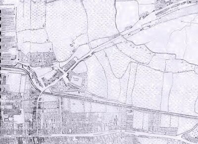
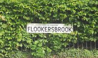
Flookersbrook (the area of modern Hoole) takes its name from the eponymous stream that ran nearby. A stream where fisherman or “Flukers” (fluke-catchers) as they were sometimes locally known, cast their nets. As late as 1643-5 Roger Hurleton late of the city of Chester held several fisheries in the River Dee with:
- "Flookenetts, draught netts, stall netts, &c."
Fluke is Old English "flocere", Medieval English "flokere" and also Old Norse "flokari". The earliest known owner of land at Flookersbrook was Arni of Neston (see: "Open Doomesday" - and his lands passed to William son of Nigel, or FitzNigel. Arni is possibly a Viking name, and it has been suggested, in "Viking Wirral" that his burial place is at "Arnehow" at Oxton - now a park known as "The Arno". William FitzNigel is probaly the same who succeeded his father Nigel as baron of Halton and Constable of Chester. His gift to St Werburgh’s of "Neutona" (Newton by Chester, a manor of 1 hide) with the service of Hugh fitz Udard, was included in the forged confirmation of Richard of Avranches dated 1119 (Barraclough, Charters of the Earls of Chester, 14–16, no. 8). A posibly also forged confirmation in the name of Ranulph De Gernon adds the information that his deed was witnessed by Ralph the steward.
Opinions differ as to what was actually known as "Flookersbrook". Some evidence points to the name being applied to the stretch from the modern-day Flookersbrook to what was Bache Pool, all of which now runs through an underground culvert, passing beneath Brook Lane (hence the name) near its present day railway bridge, and running along the edge of the supermarket car-park to emerge just to the west of Liverpool road (where it cuts visibly through the Bunter sandstone). Other evidence also applies the name Flookersbrook to the section of brook which ran somewhere along where Lightfoot street and the railway now lie. Given that building railways and railway stations requires the purchase of land, Chester Station was built on what was then the edge of the built-up area, near a stream which marked the boundary and was reached by the appropriately named Brook Street - which led to the original hamlet of Flookersbrook.
The two bodies of water which were connected by this brook were Bache Pool and St Annes Lakes. St Annes Lakes were located roughly where the enclosed wooded areas near the northern end of Hoole railway bridge now lie (they also give rise to the name of the proposed "St Anne's House" development, and before that to St Anne's street which runs from near Northgate towards Hoole), and was the site of a shrine errected for the convenience of superstitious travelers about to pass through what in medieval times was known as the "Valley of the Demons" (modern day Hoole) and especially Newton Hollows. Some believe that the statue was a re-used work from Roman Chester, whereas others believe that it was not a figure but a cross errected by the "Guild or Fraternity of St. Anne", which had close links with the vicars of St Johns, and was apparently founded in 1361 and refounded in 1393.
Their property included property in Hoole:
- "Possessions of the Fraternity of Saint Anne in the City of Chester." (First Account.) "Rents and farms in the City " Saynt Anne's House with houses, gardens, ftc., demised 12 Feb. 1 Edw. iv. for the term of 100 years. Foregate Strete. Cowlane. Seynt Johns Lane. Estgate Strete. Castell Lane. Iremonger Rowe. Northgate Strete. Parsons Lane. Watergate Streete." The messuages and tenements here mentioned are entered as leased to divers persons for terms of years, at various dates from the reign of Edw. iv." - "Rentes and farms in divers towns called Felde Renttes " Newton. Hole near Chester. Annes Heye near Seynt Annes Crosse" ("Hole" is "Hoole")
The Fraternity of St Anne was so much feared as a wealthy agency supporting ‘superstitious uses’ that in the last year of Henry VIII and the first year of Edward VI two Acts were passed which suppressed all such fraternities, and, conveniently, appropriated their property to the Crown. The Fraternity of St Anne was dissolved in 1547 and their building in Grosvenor Park was purchased by Sir Hugh Cholmondeley and converted into his town house (destroyed in the Civil War). The land at Flookersbrook was held by the Massey family of Kelsall prior to 1450 and later passed to the Bruens of Tarvin and the Sneyds before being bought by Sir Lawrence Smith of Hough, 1516–82 (1st MP for Chester 1545). He built the first Flookersbrook Hall, slightly to the north of the present Hall, which remained in that family until just after the Civil War, although the Hall itself was burned down during the Civil War as part of a "scorched-earth" policy by the defenders of Chester. The hall had been rebuilt by 1686 when Roger Whitley recorded dining there in his diary:
- "November 30. Tuesday, I went to Chester with Mainwaring in the coach to meete the Bishop; the rest went on horseback; we met the Bishop at Flooke Brooke; brought him to the Palace; stayd ½ houer with him; went back to Flooke Brook; there was Hurleston, his sonne, Griffith, Minshall, Mainwaring, my sonne, Swetnam, Morgan &c. dined there, parted about 5; went to the Sunne; there we found G.Mainwaring, Edwards, Lloyd, Murrey, Golborne, Ravenscroft; we parted at 10; I lay at Doctor Angells."
Bache Pool was the site of the watermill which Richard of Avranches donated to the Abbey in or shortly before 1151. The pool existed since prehistoric times, but the millpond was allowed to silt after 1845 and finally filled-in around 1883. The only memory of it today is "The Mill @ Upton" a recently (2017) renamed/refurbished local pub. Richard of Avranches died by drowning in the wreck of the "White Ship" together with the heir to the throne. After Henry I heard of the disaster, it is said that he never smiled again. Desperate to secure his family's succession, he had the English barons swear an oath to uphold the rights of his only remaining legitimate child: his daughter Matilda who they were to recognise as their Queen after Henry's death. The time had not yet come for a woman to be accepted on the English throne, so when King Henry died (in December 1135), his nephew, Stephen of Blois (grandson of William the Conqueror through his daughter Adela) siezed the crown and four years later, the status quo degenerated into a patchy Civil War generally known as "The Anarchy".
So how did it come to be that "Flookers Brook" was thought to flow north-to-south and not east-to-west? Already by 1789 a map by James Hunt has the brook labled as flowing east-west, while the road to the north is named as Flookersbrook. The answer may also lie in the Flookersbrook Improvement Act, 1876, which related to:
- "Such of the lands situate in the townships of Newton and Hoole and county of Chester, comprising in the whole two acres two roods and three perches or thereabouts, bounded as follows; ...and on the north-west in part by property belonging or reputed to belong to the said Earl of Kilmorey, on the other part by property belonging or reputed to belong to the trustees of the will of the late John Lightfoot, in other part by property belonging or reputed to belong to the trustees of the settlement made on the marriage of the late Maria Broadbent, in other part by a certain street or occupation road, ..."
The John Lightfoot saga was a court case which went on for very many years. Lightfoot Street is named after John Lightfoot (licensee of the Ermine, Flookersbrook, from 1818 to 1820). He died leaving everything to his son, but was not aware that his son had pre-deceased him by a few days. The consequent litigation was complicated by the fact that Lightfoot had sold land on which much of "Flookersbrook" had been built. When the matter was finally settled, many years later, the original deeds of the houses in Halkyn Road and nearby record a huge number of signatures to put the matter to bed.
A complex set of Bylaws accompanied the Act, and these hint that the streamm used to be somewhat larger. The Bylaws approved in October 1876 stated that it was an offence to
- "fish with net or rod or in any other way interfere with the fish or water fowl".
Robert L. Jones, station manager at Chester Station and resident of Hoole lived in the same house, Brook Lodge, that had been occupied by John Broster, printer and writer of guidebooks on Chester. The house has since been demolished. Jones is associated with the electrical regulation of clocks and invented a system used for the Liverpool-Holyhead telegraph line through Hilbre Island and used elsewhere.
Flookersbrook Hamlet
Hemingway writing in 1831 describes this part of Hoole as follows (listing a lot of people he probably knew and hoped would buy his book!):
- ..the lovely hamlet of Flookersbrook abounding with neatly built modern dwellings to which if the epithet of splendid be inappropriate the claim of elegance and comfort is justly due to each of which is appended richly cultivated garden ground. Here are the comfortable residences of Major Cotton the Rev John Thorpe, Mr John Williamson, Mr Cross, Mr Lightfoot, Mr T Walker, Alderman Broater, Mr Humble &c &c. It is hardly possible to pass this approach to the city without being reminded of the villas in the neighbourhood of the metropolis - the width of the road the respectable and good looking tavern called the Ermine - the pool of water in front of an excellent footpath on the north side of the road over hung with willow trees and the clean and rural appearance of the neighbouring cottages all all have ever contributed to fix an impression upon my mind such as I have just stated.
Bache Brook
Bache Brook still runs above the surface from the site of Bache Pool to the Parkgate road. Bache is generally referred to as "the Bache". The origins of the name could be "Batch" (a sandbank or patch of ground near a river), Bach (Teuton for a brook) or Bache (the Saxon denomination of a valley). Other possible meanings are a beach, strand or ford. The Bache Pool is mentioned several times "in the preambulatlon to the boundaries" of St. Oswald's from 1656. Before 1700: Flint tools were apparently discovered at the Bache Pool. Randle Holme III noted:
- "Chantrells was possessors of it for many descents. William Chantrell sould it to Edward Whitby, recorder of Chester. But the Pool is the boundery of the Liberty of the Citty of Chester upon which is a water milne; and all along the banks of the said pool from Ston bridg to the said pool and so along the side of the rivolet to Flokersbrook."
Bache Brook ran into the Dee just under the Bache and a large portion of the Bache land was presumably once the actual river beach.
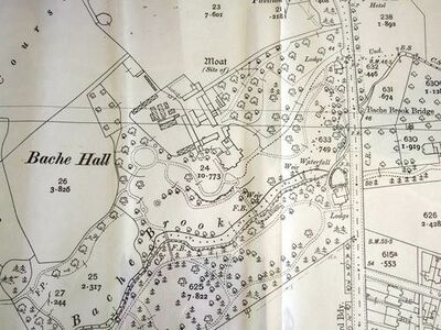
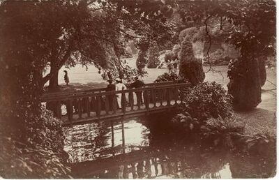
The current Bache Hall, built in the early 18th century as a gentleman's estate continued in that form until 1902 when for 10 years it became Chester Golf Club with a 9-hole course. It is now used by Chester University. The grounds used the natural features of a valley with Bache Brook draining an adjoining pool. The Hall, situated on a gentle rise, looked over pleasant gardens, well planted with trees, a waterfall and bridges over the brook. Some of the grounds were lost in the 1980s due to road widening and then a major new road (Countess Way) was built which required landfill and culverting of the stream.
The first references to the various families who have held the manor start in the 13th century with several people with Bache as a surname. It is probable that they did represent the owners but that is not definite. But by the 14th century the manor was held by the Donecaster family who had obtained land from families in Upton during the reign of Edward II. The much respected Chantrell family came next and they held the manor from the Abbot and Convent of St Werburghs and after the reformation from the Dean and Chapter.
In 1606 it was purchased by the unfortunate Edward Whitby. The property was rebuilt after the old house was demolished during the 1643 - 46 siege of Chester in the Civil War, when it was garrisoned by Parliamentary troops. Edward Whitby, who was recorder to the City at the time, was one of several who lost their houses this way around the periphery of the city. The older property is listed as having a Medieval moat, but there is no trace of it but the name Moat Field is recorded on the tithe map of 1844 (field No3, on tithe map). The site is now covered by modern houses.
From the Whitby's the estate passed partly by purchase and partly by marriage to the Cromptons. About 1716 the manor passed via an heiress of the Cromptons to the Morgans of Golden Grove in Flintshire (the same Morgan family as those of "Morgsn's Mount" on the City Walls), until they sold it to Samuel James Brodhurst of Chester. In April 1840 General Sir Charles James Napier was posted to Chester Castle with a force of cavalty and troops to quell possible "Chartist" riots. He initially tried to rent Bache Hall:
- "Chester — A fine old town. Saw a capital house if we can get it, Baitche Hall. I feel light at heart with the idea of quitting the baker's shop in Wheelersgate Street Notts, though Charles the First did lodge there — loaves lodge there now."
..but did not succeed as he could not guarantee to rent for three years. The property descended successfully to various members of the Brodhurst family who as part of the will terms had to change their name from Jenks to Brodhurst (sometimes listed as Broadhurst). Hanshall writes:
- "A stream which passes thro the Bache Pool gives feature to the immediate scenery The now occupied by Mr Dodd skinner to the Monastery of Chester as before mentioned Richard the second local Earl and passed with lands to the Dean and Chapter from whom purchased by Mr Broadhurst."
In 1874 Samuel Broadhurst Hill sold the estate to the soap tycoon Robert Spear Hudson (see 1881 census return for Bache hall and Bache Cottage). After his death in 1884 his widow, Emily, continued to live at the Hall until her death in 1901. The Hall and land was then tenanted by Major John Macgillicuddy who was one of the founders of the Bache Golf Club.
Finchett's Gutter
Finchett's Gutter continues the boundary beyond Parkgate Road, meandering through a low-lying often flooded area known as Abbots Meads. It passes under the cyclepath near Chester University main campus. under the Canal and meanders along the edge of the allotments then passes then end of Finchett Drive. The course of the gutter seems to have been modified in places as the "Stone Bridge" which crossed it would now be located on the corner of the small park on Cheyney Road. Indeed the stonework on either side of the turn in Cheyney Road is believed to be a remnant of the bridge. The earliest reference to a bridge at this location is between 1220-1250 when it was known as Wyardesbrugge, a name that is partly Old English in origin and this might suggest a bridge was there much earlier in the medieval period.
The gutter finaly reaches the River Dee at "The Cop", where a small bridge on Sealand Road crosses it. The "Sealand Main Drain" (a land drainage ditch) enters the gutter and together these form an important part of the local flood protection scheme for the reclaimed land in what was once a tidal estuary. Saughall road at the foot of foot of what was once Blacon Point would have marked the place where the brook entered the River Dee, and some old references indicate that there was a stone bridge at or near this point. When the Dee estuary was reclaimed Chester grabbed a little more land on the outer side of Finchett's Gutter, but for some time this was the border with Wales. A few hundred yards away the canal also reaches the river having taken the more direct route past Chester's highest ground at Northgate with the aid of gunpowder.
Peter Burdett was one of several map-makers who responded to the Royal Society’s 1759 appeal for accurate county surveys to be produced at a scale of 1” to the mile. Awards of £100 were granted to a few successful cartographers, one of which was Burdett for his map of Derbyshire (1767). Unable to get the necessary financial backing for a map of Lancashire, Burdett turned to Cheshire, where his early survey work was carried out 1772-4. A careful surveyor, Burdett does not show Finchett's Gutter emptying into the Dee at the current location, but flowing west over the reclaimed land, from 1754, south of Blacon Point to actually empty into the Dee at Sandycroft. Christopher Greenwood's later map of 1819 shows the gutter emptying into the Dee at the current location. This change of course eventually became responsible for a shift in the municipal boundary such that a significant part of land around the Sealand Industrial Estate became part of Chester. The gutter cannot have used the longer route for very long as Samuel Weston very shortly after Burdett's survey proposed to take the line of the canal through that of the sluices. A "sluice house" was provided for the sluice-keeper so that the sluices could be opened and closed with the tides: this is shown in Mutlow and StockdaIes Map of 1795. Some early maps seem to get very confused about the course of Flookersbrook: Ormerod even has the River Gowy spliting in two and flowing through the Backford Gap into the River Dee via Bache Brook.
The "Finchetts Gutter Water Body" has a poor ecological status according to Government Data.
An old description of the boundary of Chester

The first recorded viewing of Chester’s boundaries was carried out by the Black Prince’s Officials in 1351/53 and a description of the boundaries is contained in the Charter which the Prince issued to the City on March 9, 1354. Hemingway provides the following document from the records of the Corporation which defines:
- "..the ancient boundaries of the liberties of the city. It may here be remarked that these boundaries were first prescribed by Edward Prince of Wales and Earl of Chester son of Edw III but the document here introduced bears the date of 1539."
The part referring to the northern boundary (as discussed above) is in bold.
- "That is to wit from the Iron Bridge to Claverton highway and so over the said way to a certain siche which goeth thro the meadows of a green croft of our Sovereign Lord the King late of the monastry of the Nuns of the city of Chester and now in the holding and occupation of one Matthew Ellis and so extending by a certain siche or ditch called the Mire Dyche and other waste called the Gray Dyche being between our Sovereign Lord the King's lands late of the monastry of the Nuns aforesaid upon the north part and the lands of William Lorrenson of the south part and this is the east end of the said gray dich and at the west end thence following the same dich lyeth between Peers Dutton's lands of the north part and our said Sovereign Lord the King's lands of the late Nuns aforesaid upon the south part and so from thence straight over Broomfield highway unto a certain close in the lordship of the Lache now our said Sovereign Lord the King's and so following there a like gray ditch unto the west part of a field called Swartyne field and then follow the said ditch northward till you come to the Earl of Oxford's land sometime the land of Robert Bradford and then follow another like ditch westward lying between the said earl's lands on the north part and over our said Sovereign the King's lands on the south part and following along the same ditch between our said Sovereign's lands and the said earl's lands unto you come to a ditch in old time called a syche which syche and ditch goeth northward unto Kynarton lane the way from Chester and upon the east part of the same syche or dyche lyeth the said Earl of Oxford's lands and upon the west part of the said ditch or syche lyeth our said Sovereign Lord the King's lands and over that way westward follow a lane through the town of Lache between our said Sovereign Lord the King's lands late of the Nuns aforesaid lying on the west part and the said earl's lands lying on the east part and so follow the same lane tilt you come to the Lane Pool in Sahney otherwise called Blake Pool and so in following the same pool till you dome to a place where a pair of gallos standeth which place is now called Gallos pool and so follow the same pool to you come to the river of Dee and so on the river of Dee to Pool bridge which is now called Port poole and so follow that river to a stone bridge being in Mollington highway and from thence up a little syche or river unto Bache Pool and from thence up a little syche or river called Newton Brook and so follow the same syche or river unto Flookersbrook unto a place called Bispaditch between the lands of the King's College of Saint Werburgh's of the city of Chester on the southeast part and the Spittal field upon the north west part and so follow that ditch southward to the highway from Tarvin unto you come to a certain ditch of the east part of the chappel of Boughton and so follow that ditch unto a highway that leads from Chester towards Tarporley and so over that highway to Amourstone Lenny the lepor's houses on the west part unto the holyway that leads unto Butterbeach under the hill of the water of Dee and so in following the river of that water unto Huntindon Wood and from thence unto the Iron Bridge aforesaid."

The reference to an Iron Bridge from 1539 seems odd (as the first Iron Bridge was only attempted in 1755), but this is probably a reference to Heronbridge.
Beating the Bounds
This was an ancient custom in some parts of England, including in Chester. The custom dates from Anglo-Saxon times, as it is mentioned in laws of Alfred the Great and Æthelstan. It is thought that it may have been derived from the Roman "Terminalia", a festival celebrated on February 22 in honour of Terminus, the god of landmarks, to whom cakes and wine were offered while sports and dancing took place at the boundaries. During the event, a group of prominent citizens from the community will walk the geographic boundaries of their locality, for the purpose of maintaining the memory of the precise location of these boundaries.
The boundary was identical to that defined in 1354 when it was viewed by the mayor in 1540, with changes only in some of the landmarks and minor place-names. For example a lane now ran along the boundary from Lache Lane to the "Black pool", while a gallows stood by Black pool further towards the Dee, giving that part of the creek the name of "Gallows pool". On the north bank of the Dee the 16th-century name for the lowest reach of Flooker's brook was Portpool, and east of Bache pool it was called Newton brook. East of St. Giles's the boundary was marked by a merestone. By 1573 the point where the boundary crossed the Chester-Wrexham road was known as Hangman's hill, though the gallows which had once stood there had been removed.
While modern surveying techniques have rendered these ceremonial walks largely irrelevant, the practice often remains as an important local civic ceremony, and in some cases remains a legal requirement for civic leaders. It was usual to make a formal perambulation of the parish boundaries on Ascension Day or during Rogation week. Knowledge of the limits of each parish needed to be handed down so that such matters as liability to contribute to the repair of the church, and the right to be buried within the churchyard were not disputed. The priest of the parish with the churchwardens and the parochial officials headed a crowd of boys who, armed with green boughs, usually birch or willow, beat the parish boundary markers with them. Sometimes the boys were themselves whipped or even violently bumped on the boundary-stones to make them remember. The object of taking boys along is supposed to ensure that witnesses to the boundaries should survive as long as possible.
In Chester, the earliest recorded instance of "beating" dates from the time of Henry Gee, in 1540. The ceremony has been performed on acattered occasions since but has never become an established tradition: on 7 October 1972 Mayor C. N. Ribbeck enacted the ceremony for the first time since Mayor Dutton had in 1913 (he himself had revived it after 40 years). In Chester, beating the bounds was also an opportunity for mayors to leave their mark on the landscape, by having boundary stones errected with their initials and the date. For example, there is a stone near the Duke's Drive at Heronbridge which bears the characters "PE M 1857" . It is actually one of a whole string of such markers along the southern border of the city of which the 1911 OS map records fourteen such stones (about nine can still be found), of which Ribbeck has one later stone marked "CNR Mayor 1972".
The initials are probably those of P(eter) E(aton) M(ayor), who held the post in 1857. He was also an Alderman of Chester in the 1860 directory. He started as a brewer near the Falcon, later he was a brewer in Northgate Street and also had a fire assurance business there as well. He is buried in Overleigh Cemetery (S2993). Eaton's Brewery eventually took over the Kelsterton and St. Winnifred's (Holywell) breweries and the company was bought out in 1864 by Henry Ford, Frederic Gunton and William Kelly, who formed the Northgate Brewing Company in 1889. They had 'bottling stores, wine and spirit vaults' at 7, Foregate Street and malt kilns on the east side of Lower Bridge Street (possibly at "Rotten Row") and owned pubs throughout Cheshire and North Wales. Eaton's name can be found scattered through the city records but it is his erection of a boundary marker which has secured his place in landscape history.
The stones along the southern boundary are placed on or near the "Great Ditch". There is not much of a ditch today, but it has been speculated that the ditch may have formed the boundary of the Roman "Prata Legionis", an area around the legionary fort controlled by the legion, and in territory belonging to the civitas Cornoviorum. However the area of the "prata" may have been much larger. One reason for some form of defined region reaching up the river as far as Heronbridge may be that the river between that point and the Old Dee Bridge could well have been poorly navigable prior to the construction of the weir. This could well have required goods being shipped downriver to have been landed at Heronbridge and then required portage overland.
Other possible "boundary" markers have not been fully explained. There is a prominent (if seldom noticed) red sandstone marker at the north end of Hoole railway bridge which appears to bear the inscription "FT 1870". This is very close to where the buried Flookersbrook passes under the road, but there was no mayor of Chester at that time with the initials "FT". It has been suggested that these letters could stand for "Frodsham Turnpike", "Flookersbrook Trust" or even "Flookersbrook Township" (which does not appear to have existed). The OS map surveyed in 1873 shows a pluratity of boundary markers, "trig points" and "stones" in the vicinity, but the precise nature of this particular lump of rock and the motives of those who made and placed it have not been established.

sources and links
Related Pages
Online
- Flookersbrook blog;
- Hoole roundabout sept 2017;
- Finchett's Gutter habitat improvements (site closed due to cuts to environmental budget);
- Bache Hall at "Parks and Gardens UK";
- Thomas Walker of Flookersbrook;
- Chester Antiquary on the southern boundary marker stones and the "Great Ditch";
- Chester Photographic Survey;
- Cheshire Sheaf: see page 30;
- Parish and Township in Cheshire and North-East Wales;
- ASPECTS OF THE TOPOGRAPHY OF EARLY MEDIEVAL CHESTER;
- Local government and public services: Boundaries;

