Database changes have finished applying - please report any issues you're (still) seeing to support@shoutwiki.com.
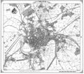
Smith Map
Overview
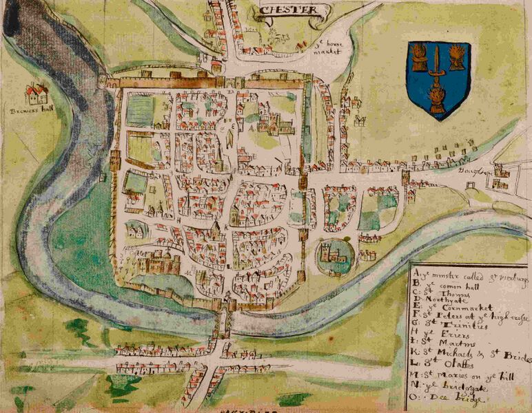
Smith's map of 1585/8 shows only a few changes from the Braun and Hogenberg map of 1581. One notable change is that the arch under the spur-wall leading to the Watertower appears to have dried.
Description of Chester
- "Chester is a most ancient & famous cittie, standing uppon the river of Dee, which is there about 200 foote brode, over the which there is a fayre stone bridge of 8 arches. The castell standeth on a hill within the walles, which walles are in compass round about 2000 paces, which is two myles, and hath 4 principall gates, with very fayre & large suburbes. The barres of the citties are of stone : within the liberties of the cittie are 9 parish churches, besydes chapells & other religious places. The howses are builded in such sort, that a man may go from one place of the cittie to another and never come into the streetes, which manner of building I have not hard of in any other place of Christendome. The said river of Dee springeth in Merinothshyre, & passeth throwgh a lake called Lhin Tegill, after (receving dyvers rivers by tht way) it entreth throwgh Denbighshyre, where (so soone as it hath recei'ed the river of Keriog) it parteth Shropshyre from Denbighshyre, & after hath Flintshire on the right syde & Denbighshyre on the left, vntill it come almost to Shocklidge, where it parteth Cheshire from Denbighshire, vntill it come 2 mylcs beneath Holt Castell, and then for the space of a myle parteth Flintshire from Cheshire, & after hath Cheshyre on both sydes ; lastly it touchcth on the south syde of the cittie of Chester, where (after it hath passed the bridge) it fetcheth a round compasse, making a fayre playne called The Rood Eie, toucheth also on the west syde of the cittie. And after it is past the New Tower of the said cittie, it becommeth alwaies broder and broder, vntill it fall into the sea, which is 16 myles from Chester."
Features
- The "Horse Market" at Gorse Stacks has become a huge feature. It is not clear whether the road leading to the upper right from it is Brook Street or St Anne Street.
- Two towers are shown between the Phoenix Tower and the Northgate. These are not shown on other maps and there is no evidence that they existed in the 16thCent., although there were Roman towers along this section of wall.
- Building on the east-side of Northgate Street is not continuous. It has been suggested that at an earlier date this was simply a wall marking the boundary of the Cathedral quarter.
- "Brewers Hall" is shown for the first time. The estate, which lay west of the city on the river cliff overlooking the Roodee, was held by the Bradford family, serjeants of the Eastgate from the 1280s. It passed to the Trussell family of Warmingham in the 14th century and from them c. 1500 to the Veres, earls of Oxford. After its sale by Edward de Vere, 17th earl, in 1580, it passed successively to Hugh Beeston, Sir Thomas Egerton, and the Wright family, whose descendant sold it in the mid 18th century to William Hanmer of Iscoyd (Flints.). Hanmer's daughter Esther married Assheton Curzon, later 1st Viscount Curzon, whose grandson and heir R. W. P. Curzon-Howe, 1st Earl Howe, developed the estate as Curzon Park, then disparaged as 'a cold bleak hill', in the 1840s. The ancient mansion was demolished during the siege of Chester and was afterwards replaced by a farmhouse. Nowadays, a golf-club stands on the site.;
- Shipgate is not shown, but the Capelgate next to the Watergate is;
- Love Street and Dee Lane possibly appear, as does Garden Lane;
- The Bars are shown, as are the gallows at Boughton: this was the place of Execution at Chester.
History
William Smith’s (1588) plan of Chester from his “The Particuler Description of England With the portratures of certaine of the cheiffest citties & townes” (Source: British Library, Harley MS 1046, fol. 173)
William Smith, (not to be confused with the 18th century William Smith “Father of English Geology” - also a famous map-maker), was an antiquarian and "Rouge Dragon" at the College of Heralds/College of Arms (1597–1618). This was an institution that specialized in genealogical work, increasingly more so during the Elizabethan age as the gentry class rose in importance. The "Rouge Dragon" is the name of one of the Pursuivants, a heraldic officer attendant on the heralds, often attached to a particular nobleman, named so because of their badges.
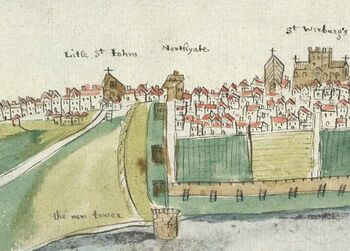
In 1588 Smith completed "The Particuler Description of England. With the portratures of certaine of the cheiffest citties & townes". This work consisted of drawings of English cities and towns in a traditional bird's eye view style, and combination drawings amalgamating the bird's eye view and plan. He is also credited with a drawing of Chester, dating from 1585 and possibly a preparatory drawing for the map. It shows Chester as a walled city. The prominent coat of arms reveals Smith's heraldic interests.
In the year 1602-03 William Smith anonymously published maps of Chester, Essex, Hertfordshire Lancashire, Leicester, Norfolk, Northamptonshire, Staffordshire, Suffolk, Surrey, Warwickshire and Worcester. These were probably engraved in Amsterdam and were intended to form sheets of a new atlas. After the publication of Christopher Saxton’s county maps in the 1570s, cartographers attempted to improve on Saxton’s atlas and replicate its success. Unfortunately for Smith, another cartographer, John Speed (who was from Farndon), was also preparing county maps at that time and competition proved too great, Speed being the victor.
Smith's Written Description of Chester
Smith also produced a written description of Chester. This is somewhat longer than the single paragraph in his "Particular Description". It reads:
"The Walles of the Cittie, containe at this present day in Circuite Two English myles. Within the which in some places, there is certayne void ground and Corne feilds, Wherby (as also certaine Ruines of Churches, and such Lyke great places of Stone) it Appeareth that the same was, in old tyme all Inhabited. But Looke what it wanteth at this day within the walles: It hath without, In very faire and Large Suburbes.
It hath foure principall gates. The Estyate, towards the Est. The Bridge gate, towards the Sowth. The Watergate towardes the West. And the Northyate towardes the North. These gates in tymes past, and yet still, according to an Antient order used here in this Cittie: Are in the protection or deffence, of dyvers noble men, Which hold, or have their Landes Lying within the Countie pallatine.
As first, the Erle of oxford, had (till of Late yeares, but now Sir Christopher Hatton) the Estyate. The Erle of Shrewsbury, the Bridge gate. The Erle of Darby hath the Watergate, who in the Right of the Castell of Hawarden (not farr of) is Steward of the Countie pallatine. And the northyate belongeth to the Cittie, where they kepe their prisoners. The Estyate, is the fayrest of all the Rest. ffrom which gate to the Barres (which are also of Stone) I ffynd to be 160 paces of geometrie, And from the Barrs, to Boughton almost as much.
Besydes these 4 principall gates: There are certaine other lesser, Lyke postern gates, And namely St. John's gate, betwene Estyate and Bridge gate, So called, because it goeth to the said Church of St. John, which standeth without the walles.
The Bridge gate, is at the Southpart of the Cittie, At the entring of the bridge (Comonly called Dee Bridge) which Bridge is builded all of Stone, of viij. Arches in length. Att the furthest end wherof, is also a gate. And without that (on the other syde of the water) The Suburbes of the Cittie, called Handbridge. Thc Watergate, is on the west syde of the Cittie. whereunto in tymes past, great Shipps and vessells might come, at a full Sea. But now scarce small boates are able to come, The Sandes have so Choaked the Chanell. And although the Citezens have bestowed marvelous great charges, in building The New Tower, which standeth in the very River, betwene this gate, and Northyate: yet all will not help. And therefore all the Shipps, do come to a place, called The New Kay, 6. myles from the Cittie.
The Castle of Chester, Standeth on a Rocky hill, within the Wall of the Cittie, not farr from the Bridge. Which Castell, is a place having privelege of it selff. And hath a Constable. The building thereof seemeth to be very Ancient. At the first coming in, is The gate house, which is a pryson for the whole County, having dyuers Roumes and Lodgings. And hard within the gate, is A howse, which was somtimes the Exchekor: but now the Custome house. Not farr from thence, in the base court, is A deepe well, and thereby, Stables and other howses of office. On the left hand is A Chapell. And hardby adioyning thervnto, The goodly ffayre and Largo Shyre hall. newly Repayred. Where all matters of Law, touching the Countie pallatine, are hard, and judically determyned. And at the end thereof is The Brave new Exchequer, for the said Countie pallatine. All these are in the Base Court.
Then there is A draw Bridge into the Innerward, wherein are dyvers fayre and pleasant Lodgings, for the justices, When they come. And herein The Constable hym selff dwelleth. The Theeves and Fellons, are Arraigned in the said Shire hall, And being Condemned: Are by the Constable of the Castell, or his deputie, delyvered to the Shireffs of the Cittie, a Certayne distance, without the Castlegate, At a Stone, called The Glovers Stone ffrom which place, The said Sheriffs do Convay them throwgh the Citty, to the place of Execution, called Boughton.
Tho Cittie is devyded into ix Parishes. The first wherof is named St. Werburgs. otherwise called The Abbay, or Minster, And is The Cathedrall Church, having the parish Church in the South yle of the same. This is a goodly, fayre and Large Cross Church, having a square Steple in the middest, And at the West end, is A Steple begon, but not halff finished. Hardby adioyning, is the Bishopps pallace, and not farr of The Deanes howse.
Tho Second parish Church, is called St. Johns. and is hard without the Walles vppon tho banck of the River Dee. A very fayre and Large Church, with a fayre brode Steple at the West end therof, Which Steple the yeare past Anno 1574, did halff of it fall downe, from the very topp to the Bottome. Two squares did fall downe, And two squares do stand still. but it is building upp agayne.
St. Peters, at the high Cross, In the middest of the Cittie, A ffayre Church, with a Spyre Steple, vnderneath which Church is The Pendice, wherof more shalbe said, shortly after.
St. Trinities, betwene St. Peters Church, and the Watergate, A ffayre Church, with a Spyre Steple also.
St. Michaells, in the Bridge Strete.
St. Brydes, Right over against St. Michaells.
St. Olaffs, comonly called St.Tolas, in the same streete nerer to the Bridge.
St. Maries, on the Hill, by the Castle gate, a very ffayre with a square brode Steple. In which Church are certayne fayre Tombes, of dyvers gentlemen, and ospecially of the Troutbecks, Who (as it should appeare) Were ffounders therof.
St. Martins, not farr from the freres, towards the west part of the Cittie.
St. Thomas, without Northyate.
OF THE MAIOR, ALDERMEN AND SHERIFFS OF THE CITTIE, ETC. The Estate that the Maior of Chester kepeth is great. ffor he hath both Swordbearer, Macebearer, Sergeants with their Silver Maces, in as good and Decent order, as in any other Cittie of England. His howsekeping accordingly, but not so Chargeable, as in some other Citties, because all things are bettor cheape there.
He Remayneth most part of the day, at a place called The Pendice. Which is a brave place, builded for the purpose, at the High Cross, vnder St. Peters Church. And in the Middest of the Cittie, In such sort, that a man may stand therein, and see into the Marketts, or 4. principall streets of the Cittie. There was wont to sitt also (in a Roume adioyning) the clarks of the said Maiors Courts, Where all actions Were entred, Recognizances made, and such Iyke, but this is now Removed into the Comon Hall of the cittie.
There is none chosen alderman, except he have byn first Maior. The Sheriffs (as also the Maior) on the workdaies, do go in fayre Long gownes, Welted with velvet, and Whyte staves in their handes. But they have Violett and Scarlett also, for festival daies.
Not farr from the Pendice, towardes the Abbay Gate is The Comon Hall, of the Cittie, Which is a very great howse of Stone. And serveth in stead of their guildhall, or Towne house.
The Buildings of the Cittie are very Antient. And the howses build in such sort: that a man may go dry, from one part of the Cittie, to another, and never come in the street, But go, as it were in galleries, which they call The Roes which have Shopps, on both sydes, and vnderneath, with dyvors stayres to go vpp and downe, into the streets. Which maner of building, I have not hard of, in any p]ace of Christendome. Some will ay, that the Lyke is at Padua in Italy. But that is not so, for the howses at Padua, are builded, as tho Suburbes of this Cittie be, that is on the ground, vppon posts, that a man may go dry Vnderneth them, Lyke as they are at Billings gate in London. But nothing Lyke to these Roes. It is a goodly sight, to see the nomber of fayre Shopps that are in these Roes, of Mercers, grocers, Drapers and Haberdashers. Especially in the Street called the Mercers Row. Which Street, with the Bridgestreet (being all one street) reacheth from the High Cross, to the Bridge, in Length 380 paces of geometry, Which is above a quarter of A myle.
There are certayne Conduits of freshwater. And now of Late (following the example of London) they have builded one, at the High Cross, in the middest of the Cittie, And bring the water to it, from Boughton."
Sources and Links
Related Pages
Online
- Smith's drawing;
- The particular description of England. 1588 (see page 44 for Chester);
- William Smith: at DNBE;
A gallery of Old Maps of Chester
Braun and Hogenberg (1581)
Smith Map (c.1588)
John Speed (c.1610)
Hollar's Map (1660's)
Lavaux Map (1745)
Hunter Map (1789)
Mutlow and StockdaIes Map (1795)
Coles Map (c.1804)
John Webb Map (1833)
Hugh Roberts (1858)


