Braun and Hogenberg
Overview
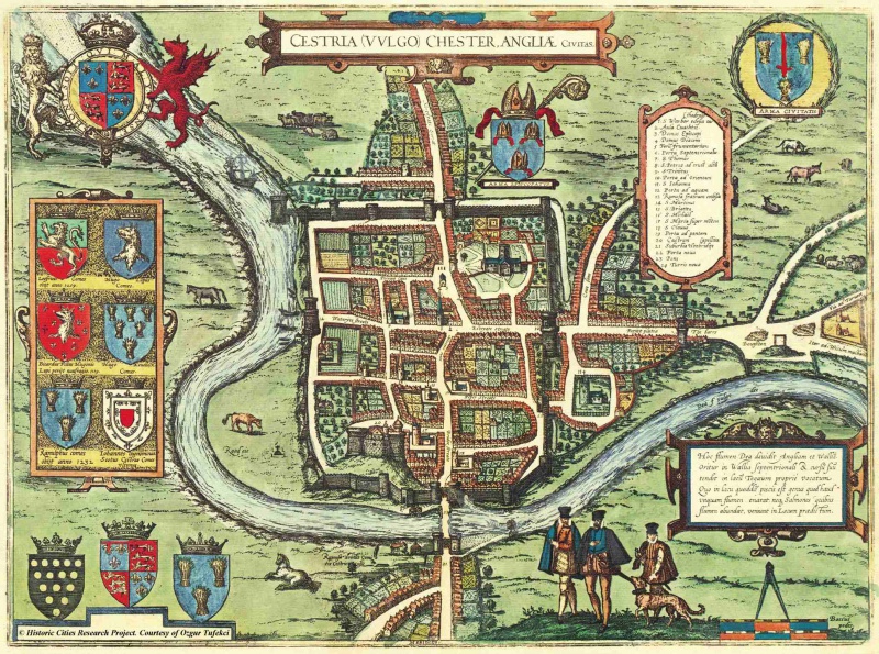
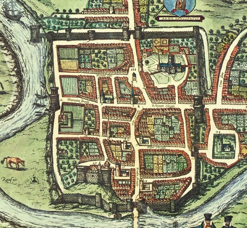
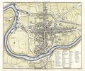
The Braun and Hogenberg map of Chester is the first known detailed map of the city. It dates from 1581. 1581 was in the middle of the reign of Elizabeth I. Chester's population in 1563 of c. 4,700-5,200, which put it in the second rank of provincial towns, half the size of York and a third that of Norwich. Within the North-West, however, it was the largest town for sixty miles around. Frances Drake had just sailed around the world and the Nederlands had declared independence from Spain. Much of the city within the City Walls is undeveloped, with building restricted to narrow frontages along the principal streets. Much of the street pattern is recognisible as similar to that of modern Chester. The principal streets (Eastgate Street, Northgate Street, Watergate Street and Bridge Street) follow the line of the major internal roads of Roman Chester, with the familiar "dog-leg" at the High Cross. The bounds of Roman Chester are marked-out by Trinity Street, Weaver Street, Cuppin Street, and Pepper Street, with the Roman walls along those sections robbed-out and the Anglo-Saxon walls extended down to the River Dee: west to the Watertower and south from Newgate.
It is after the Reformation, so the "monastic" lands to the west of the city centre have been sold-off. Much of the area between the walls and Nicholas Street will remain as open fields until the 18th to 20th centuries. Its history has also been associated with major institutional uses (the friaries and the Infirmary), giving it a different history and character to most of Chester. Braun and Hogenberg shows two buildings on Nuns Road. The upper of these might be the house of the Smith family (see Greyfriars for more info) while the lowermost may be the remains of St Mary's priory. There is already development outside the walls along upper Northgate Street, Foregate Street and Frodsham Street, and in Handbridge.
At this stage there was only one bridge over the River Dee, the Old Dee Bridge. The Dee Mills have been in existence since the time of the Norman Earls of Chester.
Scattered around the map are various coats of arms, these do not include the Arms of Chester regranted in 1580, but show the older "sheaves and sword" arms on the right. The set of six arms on the left are those of the Mercian Leofric, and the Normans Hugh of Avranches, Richard of Avranches who's death on the "White Ship" is mentioned, Hugh de Kevelioc, Ranulf de Blondeville and John Canmore, although Canmore's arms are different from those usually given. The arms with the 15 gold coins at the lower left is that of the Dutchy of Cornwall and the ones next to it those of the Prince of Wales and the Earl of Chester. There was however no Prince of Wales at the time as Elizabeth was childless. The latin caption explains how the River Dee rises in Wales and flows through Bala Lake.
Features
Braun and Hogenberg's map of Chester dates from 1581. The following can be seen on the map:

- The gallows at Boughton (near St Giles Cemetery - whose associated buildings are shown at the edge of the map). This was the place of Execution at Chester and lay at the City limits so as to give a clear message to anyone approaching the city from that direction.;
- The Water Tower, (built 1323 and 1325 and then still known as the "New Tower") is still in the water;
- Watergate, opening directly onto the river;
- A ship at anchor at the "Portpool": the course of the River Dee downstream from Chester was always uncertain, and its shifting sandbanks were remarked upon as early as the 12th century. In the endless movement of those 'skittering sands' lay a perennial problem for the city: the maintenance of suitable anchorages to accommodate sizeable ships. By the 13th century the earliest and nearest, Portpool, had been created at the western edge of the city liberties.
- A somewhat reduced Roodee, with cross. Already present outside the Watergate is the building which probably became known as the "Pentice on the Rood-eye". This has otherwise been dated as being present in 1607, but does appear here in 1581. This "Pentice" may have started life as a toll collection place. A "keeper of the Roodee", employed by the Assembly, was housed probably from 1607 in the rooms under the "Pentice on the Roodee". The "Keeper of the Watergate", was empowered to collect taxes on goods entering the city on behalf of the Stanley's, who had probably purchased the right to collect these taxes. According to the ancient records, the keeper: "takes of every cart entering with firewood: one branch; of every horseload of fish: five fishes; of every boat coming to the aforesaid gate with large fish or salt salmon: one fish; with herring, fifty";
- In Edgar's Field, a location marked "ruin of the house of the count of Chester". Interesting that this is the only feature, apart from some street names, which merits an actual label on the map;
- The Old Dee Bridge with defensive towers at both ends;
- What appears to be St Olave Street extends through to the City Walls;
- The old market square. The City Magistrates bought the old Shire Hall at Chester Castle for six Cheshire cheeses, and moved it to the Market Square in Northgate Street where (after a short stint a granary) it became the "flesh shambles" (meat market: see: Shambles);
- All of the older church buildings within the City Walls are shown: St Peter's (with steeple - taken down in 1597) by the High Cross, Holy Trinity, St Martin, St Bridget, St Michael, St Olave and St Mary on the Hill. A tower on what is now Canal Street may be associated with St John's Hospital or possibly with St Thomas;
- Frodsham Street, leading to the cattle market at Gorse Stacks was then "Cowe Lane" (only remembered today in "Cow Lane Bridge");
- "The Barrs", has another fortified gate at the end of Foregate Street;
- St Johns, appears to have the Choir already in ruins, this was pulled down in 1581;
Commentary
The following description of the map was written by T. N. Brushfield, M.D. and published in the July 1879 edition of The Cheshire Sheaf:
- “One of the most interesting, as it is perhaps the most ancient of the engraved Plans of Chester is the one that appeared in Braun's Vivitates orbis terrarutn, published at Cologne (“Coloniae Agrippinae”) in 6 vols. folio, between the years 1523 and 1618. The Plan is No. 3 in vol. iii., and measures 14 in. by 13 in. It is headed “Cestria vulgo Chester Angliae civitas,” and bears along its upper and its left hand borders the Royal, Episcopal, and Civic Arms, together with those of the Earls of Chester. The date of this volume is 1616, that of the preceding being 1575. We may fairly assume the plan to represent the City as it was during the closing years of Elizabeth's reign, the latter part of the 16th Century- this is to some extent corroborated by the costume of certain figures depicted on the lower part of the engraving. The Plan is a bird's eye view of the City, as it would have appeared from the south side. The river channel (lettered “Dea fl. vulgo Dee") is shown to flow close up to the Water gate ("Porta ad aquam"), on either side of which several boats and small ships are moored; it then runs parallel and close to the Wall as far as the Water Tower ("Turris noua"), which is surrounded by water, some portion of which runs through two large arches in the masonry connecting this Tower with the main Wall; near this is represented a large three-masted ship with high poop. The Bridge ("Pons") over the Dee is defended at the Handbridge end by a strong entrance gateway, to the West of which is a mill with one wheel. One with two wheels occupies the site of the present Dee Mills. In the Wall, close to the eastern side of the Bridge gate ("Porta ad pontem”), is an archway from whioh water is issuing: may not this have been the termination o£ one of the subterranean Canals alluded to by Stukeley? The "Rood eie” has on it a Cross elevated on a base of three or four steps, and guarded by pillars at each corner. The Walls are embattled. The four principal gateways, as well as the one at "The barrs," each consist of two castellated towers, with an archway for the road between them, those guarding the Dee Bridge having a portcullis. Between the Eastgate (“Porta ad Orientem”) and the Barrs is "Forijat platea," (Foregate Street) out of which branches “Cowe Lane," leading to green pastures occupied by cattle. On a mound at Boughton is a gallows, and beyond this the road bifurcates into the "Via ad Taruen" and the "Iter ad Wicum malbanu”.
Brushfield is wrong about at least one thing - the "subterranean canal" is actually the "Capelgate", where horses were taken to water and nothing to do with the underground passages (see: Tunnels) which were probably Roman drains/sewers.
Explore Elizabethan Chester
Explore Queen Elizabeth I's Chester as it was in 1581 (without the plague, fear of robbery or having a building fall on you) "mouse-over" on the map below will reveal various locations. Clicking on a location will reveal more detail.
History
Georg Braun (also Brunus, Bruin; 1541 – 10 March 1622) was a topo-geographer and a cleric of Cologne. From 1572 to 1617 he edited the Civitates orbis terrarum, which contains 546 prospects, bird's-eye views and maps of cities from all around the world. He was the principal editor of the work, acquired the tables, and hired the artists. This great city atlas was largely engraved by Franz Hogenberg (1535-1590) the son of a Munich engraves who settled in Malines. Braun was greatly assisted in his project by the close, and continued interest of Abraham Ortelius, whose Theatrum Orbis Terrarum of 1570 was, as a systematic and comprehensive collection of maps of uniform style, the first true atlas. Braun died as an octogenarian in 1622, as the only survivor of the original team to witness the publication of volume VI in 1617. The first volume of the Civitates Orbis Terrarum was published in Cologne in 1572. The sixth and the final volume appeared in 1617.
The Civitates, indeed, was intended as a companion for the Theatrum, as indicated by the similarity in the titles and by contemporary references regarding the complementary nature of two works. Nevertheless, the Civitates was designs to be more popular in approach, no doubt because the novelty of a collection of city plans and views represented a more hazardous commercial undertaking than a world atlas, for which there had been a number of successful precedents. Franz Hogenberg engraved most of the plates for Ortelius's Theatrum, and may have been responsible for originating the project.
Over a hundred of different artists and cartographers, the most significant of whom was Antwerp artist Georg (Joris) Hoefnagel (1542-1600), engraved the cooper-plates of the Civitates from drawings. He not only contributed most of the original material for the Spanish and Italian towns but also reworked and modified those of other contributors. After Hoefnagel's death his son Jakob continued the work for the Civitates. A large number of Jacob van Deventer (1505-1575), also known as Jacob Roelofszof, unpublished works, plans of towns of the Netherlands were copied, as were Stumpf's woodcuts from the Schweizer Chronik of 1548, and Munster's German views from the 1550 and 1572 editions of his Cosmographia. Another important source for maps was the Danish cartographer Heinrich van Rantzau (1526-1599), beter known under his Latin name Rantzovius, who provided maps of Northern Europe, specially of Danish cities. The Civitates provided a uniquely comprehensive view of urban life at the turn of the sixteenth century. Other sources were the maps of Sebastian Munster from around 1550.
Braun added to the maps figures in local dress. Braun's motives for adding figures to the views, as stated in his introduction to book one, was that he believed that his plans would not in consequence be scrutinized for military secrets by the Turks, as their religion forbade them from looking on representations of the human form.
The plans, each accompanies by Braun's printed account of the town's history, situation and commerce, form an armchair traveler's compendium, which the scholar Robert Burton in "The Anatomy of Melancholy" of 1621 asserted would not "only provide instructions but would uplift the spirit as well".
Sources and Links
Related Pages
Online
- Images from Civitates orbis terrarum;
- Higher resolution image of the map of Chester;
- Another image of the map of Chester;
- Georg Braun on Wikpedia;
A gallery of Old Maps of Chester
Braun and Hogenberg (1581)
Smith Map (c.1588)
John Speed (c.1610)
Hollar's Map (1660's)
Lavaux Map (1745)
Hunter Map (1789)
Mutlow and StockdaIes Map (1795)
Coles Map (c.1804)
John Webb Map (1833)
Hugh Roberts (1858)
