Bridges
Chester has a surprising number of interesting bridges and part of the reason it was founded where it stands is that it was the lowest crossing point of the River Dee. Most of the common types of bridge are illustrated by the city bridges and many have an interesting story associated with them, both in terms of the history of Chester and in terms of the history of bridges in general. Chester has always lain at the convergence of many roadways, both national and local, which have both reflected and reinforced its standing as a regional capital. It was the focal point of Roman military roads in northwest Britain, several stretches of which remained in use in later centuries, often together with river crossings, notably the Dee Bridge in Chester itself. East of the city Roman roads crossed the river Gowy at the appropriately named Stamford and Trafford, later the site of fords and eventually, by the 13th century, of bridges.
The river bridges at Chester demonstrate an interesting geological puzzle as they cross what is sometimes called the "Chester Gorge", the rather deep, sandstone-sided valley in which the River Dee flows through the city. If the Grosvenor Bridge was "bricked up" to turn it into a kind of dam to hold back the River then (on the unlikely assumption that it did not collapse), the pent-up River would never rise enough to overflow it, but would find another route to the sea through Broughton. This presents a mystery as to why the river flows through Chester at all. It is possible that the gorge started life as a glacial meltwater channel similar to that at Backford, north of the city.
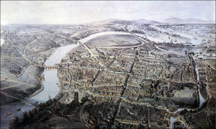
Roman and Saxon Bridges
Many references state that the Romans invented the arch bridge, however several intact arched stone bridges from the Hellenistic era can be found in the Peloponnese, dating to the Greek Bronze Age (13th century BC). Some of these might be better described as a corbel arch which is not a true arch where the support is compressed. The greatest bridge builders of antiquity were the ancient Romans, who made extensive use of the true arch, both in bridges and in buildings.
The original bridge over the Dee was built for the Romans and probably had stone piers carrying a flat timber carriageway. It is said that the remains of the bases of the Roman bridge can be seen in the riverbed just downstream of the Old Dee Bridge, although little is visible except in very dry periods with an excptionally low tide, such as in 1984 when the remains were tentatively identified. A massive stone wall in Lower Bridge Street (in front of "The Cross Keys") has been interpreted as part of a causeway leading to it, without firm evidence. Prior to the Battle of Chester (616) the Northumbrians may have crossed the Dee at Chester by a surviving Roman Bridge and made use of the Roman road to approach the battle site at Heronbridge.
The "Roman" bridge seems to have disappeared by the 10th century, as in the reign of Æthelflæd of Mercia (AD 911–918) there was apparently only a ferry. However by 1066 a new bridge had been built before the arrival of the Normans. In 1182–3, when the earldom was in royal wardship, work was done on that bridge or its successor, but by 1227 it was claimed that it had collapsed. The early bridges over the Dee at Chester were both a convenience and a source of revenue from tolls. Although Chester is often said to be the lowest point on the Dee where it can be forded this is not the case as there were fords in the Dee Estuary (near Shotwick) that could be used, although they were somewhat treacherous and constantly shifting location. It should be noted that prior to the regulation of the Dee by works at Bala Lake and the extraction of water from the river for various purposes the flow of the river at Chester would have been significantly greater as well as far more variable.
Medieval Bridges
Many medieval bridges, such as that at Chester had multiple stone arches. These were built using "falsework", a temporary structure which was usually wooden and which supported the arches while incomplete. Masonry arch bridges are designed, so far as is possible, to be constantly under compression as mortared masonry has little strength in tension. In the first compression arch bridges, a keystone in the middle of the bridge bore the weight of the rest of the bridge. The more weight that was put onto the bridge, the stronger its structure became. Masonry arch bridges use a quantity of fill material (typically compacted rubble) above the arch in order to increase this dead-weight on the bridge and prevent tension from occurring in the arch ring as loads move across the bridge.
Old Dee Bridge
(for the main article see: Old Dee Bridge)
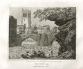
The Old Dee Bridge is often said to be the oldest bridge in the city. It crosses the River Dee carrying the road that leads from the bottom of Lower Bridge Street and the Bridgegate to Handbridge. A bridge on this site was first built in the Roman era, and the present bridge is largely the result of a major rebuilding in 1387. The bridge leading to the Watertower was built between 1323 and 1325 and so might be considered the oldest actual bridge structure in Chester, although that too has certainly been repaired. The bridge features in an absolutely stunning video reconstruction.

The Dee bridge was important for Edward I's conquests in Wales. Legend says that when King Edward I crossed over the then wooden bridge on his way to fight the Welsh, he decreed that if a stone bridge was not constructed he would sack the city - a major threat but probably necessary given that the people of Chester do not seem to have wanted to spend their own money on the bridge. However, Edward was not a king to be ignored and a first stone bridge was built shortly thereafter. The bridge was not the only route into Wales: on his Welsh campaigns of 1156 and 1165, Henry II used the adjacent Shotwick to Flint ford as his access into Wales. This would avoid taking his army through the city as well as avoiding the marshes atound Saltney.
The new work was protected by an order, promulgated in 1394 and still in force in 1533, forbidding the passage of carts with iron-bound wheels. It included a tower at the southern end, to finish which it was decided in 1407 to devote half the income from the ensuing five years' murage. That end of the bridge was again repaired or renewed at the end of the 15th century. Built of the local red sandstone, it originally consisted of eight arches, later reduced to seven (four segmental and three pointed), surmounted by a carriageway with a stone parapet; the southern gatehouse, which survived until the 1780s, stood between the sixth and seventh arches from the Chester side.
By the later 16th century the bridge was described as ruinous, and from the 1570s to the 1590s leases of the gatehouse at the southern end obliged the tenant to carry out repairs, apparently to the bridge itself as well as to the buildings upon it; in 1594, for example, the lessee Thomas Lyniall undertook to repair the structure and to build "fair and beautiful houses" on the tower and south side. Nevertheless, its condition remained a matter of civic concern and the Assembly appointed surveyors for its repair in 1623. While the present bridge has a level roadway this was apparently not always the case. During investigations of the structure trial pits were excavated over the crowns of arches 3 to 7 revealing an interesting variation in deposits under the base of the modern carriageway. In arch 5, there was a substantial surface of river cobbles. It is tempting to consider this cobble surface as the original medieval road over the bridge. It is curious that whatever its date and even though it is the central arch, this surface must have lain lower than the roadway over the adjacent arches.
During the siege of Chester the bridge seems to have sustained no permanent damage. Charles I crossed it twice in 1645, protected from the besiegers' view on his return journey by specially erected blinds; and the parliamentarians, unable to shake the citizens' hold over it, bypassed it by building a bridge of boats a short distance upstream crossing the River at Dee Lane. Towards the end of the siege the royalists countered with a sortie across the Dee Bridge and by trying to float fire boats loaded with powder against the bridge of boats, but neither venture succeeded. Even when in December ice floes temporarily broke the bridge of boats and a large detachment of the besiegers was drawn off to counter a royalist force at Whitchurch, the defenders were unable to take advantage, apart from bringing in a small quantity of wheat and oatmeal.
Towards the end of the 18th century anxiety was expressed about the narrowness and inconvenience of the bridge and its approaches. The steep descent in Lower Bridge Street was eased, the Bridgegate rebuilt, and the gatehouse at the Handbridge end demolished. Nevertheless, the structure itself remained "very narrow and dangerous". The canalization of the Dee had, no doubt, exacerbated the inconvenience to travellers, since the heavily used fords lower down the river had been replaced by less convenient ferries. Fresh complaints were voiced at a public meeting in 1818, and for some years it was debated whether the better solution would be to widen the existing bridge or to build another. Both policies were eventually adopted. In 1824 the corporation decided that care of the old bridge should be vested in the trustees of the planned new bridge, and improvements were carried out in 1826. The bridge was widened by 7 ft. on the upstream side by adding an iron-plate footpath and railings, and the road surface was macadamized. Tolls taken at the bridge tollhouse were let for over £3,000 in 1826 and 1827, but in 1829 the city judged it more profitable to retain direct control and a paid collector was appointed. Tolls continued to be levied until 1885.
A Dee Bridge Gallery
Many of the illustrations of the Old Dee Bridge show the Dee Mills, which were located on the bridge and powered by the head of water provided by the wier.
Hockenhull Platts
The three bridges over the River Gowy at Hockenhull Platts are often called the "Roman Bridges" although the structures seen today are not Roman. When work was being done to underpin the present stone structures in the 1940's some earlier timber post construction (possibly Roman) was exposed. In 1353 when Edward, the Black Prince, crossed the bridges, he ordered that 20 shillings should be spent on their repair. These bridges are a little out of town and a special excursion will be needed to see them. The three stone bridges that can be seen today were constructed around about 1470 and are typical pack horse bridges with a single arch construction. They are connected by a causeway or an embankment of over 250 metres built of earth, clay and topped with sets or cobbles.

In the 17th century the surface of the road was disintegrating so badly that posts were set into the road to prevent the passage of carts, and it could be used only by pedestrians and horses. As noted above carts took a different route. Goods were carried by convoys of packhorses led by a driver (or "Jagger") walking in front. The pioneer female traveller Celia Fiennes crossed the bridges in 1698, as did Thomas Pennant in 1780. The present bridges probably date from the latter part of the 18th century, although they are frequently referred to as the "Roman Bridges". In 1824 Cheshire County Council proposed to divert the road from Nantwich to Chester and make it pass along Platts Lane, which would have led to the destruction of the bridges. However the land on which they stood belonged to the Marquess of Westminster, and he refused permission for the road to be diverted. Some thing similar must have happened around 1901, when the local newspapers contained letters complaining about the impending removal of the bridges. Fortunately they were again saved. Today (2020), Hockenhull Platts consists of three humpback bridges which are approached and connected by causeways. The bridges are constructed from tooled blocks of red sandstone. The parapets are plain and are surmounted by chamfered coping stones which are joined by iron ties. The carriageway is formed from a mixture of stone setts and cobbles.
Grosvenor Bridge
(for the main article see: Grosvenor Bridge)
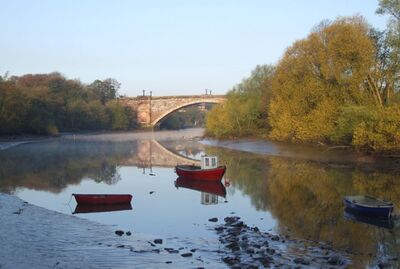
The Grosvenor Bridge, was designed by Thomas Harrison and officially opened in 1832 although it was not finished for traffic to cross it until 1 January 1834. At its opening, the Grosvenor Bridge was the longest existing single-span stone arch road bridge – at 200 feet across and 60 feet high – in the world (the Trezzo sull'Adda Bridge completed in 1377 had been longer, but was destroyed during a seige 1416). The Grosvenor Bridge held the world record for thirty years when it was surpassed by the "Cabin John Bridge" in the USA, 220 feet across and 57 feet 3 inches high. The Grosvenor Bridge is still the longest masonry arch in the UK, and (when I last looked) number 19 in the world.
One reason for building the Grosvenor Bridge was that the Old Dee Bridge was frequently congested. It has also been suggested that the construction of the bridge was prompted by the appointment of Thomas Telford in 1815 to oversee the building of what is now the A5 from Shrewsbury up to Holyhead. If this was the case the Cestrians were very slow to act. Following a public meeting at the Chester Town Hall (in those days the "Exchange") on 28th Deptember 1818 a resolution was passed that:
- "... the existing mediaeval bridge [at Handbridge] and the avenues thereto, which are the principal communication between the great manufacturing counties of Lancaster and York and the whole of the North of England, with the West of England, and with Wales and Ireland, are not only highly inconvenient but absolutely dangerous to passengers in carriages, on horseback and on foot."
It took until 1825 to get the Royal Assent to the Act providing for:
- "... the erection of an additional bridge over the River Dee in the City of Chester; for the making convenient Roads and Approaches thereto and for taking down and rebuilding the parish church of St Bridget and for repairing the present bridge."
By the time the bridge was opened almost twenty years had passed since the first concerns had been expressed about the diversion of trade via Telfords new route into Wales.
Prior to the construction of the bridge there was considerable doubt as to its structural integrity. One way that the Committee were convinced was by the constructiom of a scale model of the bridge which can srill be seen today next to the City Walls by Chester Castle. In engineering terms this borders on trickery, as the well-known Square-Cube Law demonstrates that as a model is scaled up the weight grows faster than its ability to support itself - the reason why elephants have thick legs, while ants can make do with very thin ones. In fact a scale model bridge carved from a single chunk of stone says very little about the strength of the full size equivalent bridge made from an assembly of thousands of elements of masonry.
A Grosvenor Bridge Gallery
Dee Railway Bridge
During the Industrial Revolution iron became available for the construction of bridges. At Ironbridge a 100-foot (30 m) cast iron bridge that opened in 1781 survives to this day. Casr iron is immensely strong in compression, but performs less well than steel and wrought iron when subjected to tension or bending moments, because of its brittleness and lower tensile strength. The bridge uses carpentry techniques in its construction, such as mortice and tenon joints and dovetails. Although the Ironbridge gorge bridge was an arched bridge, early Victorian iron railway bridges tended to be of the "flat" type with stone or brickwork piers supporting some arrangement of horizontal girders. During the Victorian era, high profile cast iron structural failures would shock the nation.
In late 1846, the Shrewsbury and Chester Railway, later to become part of the Great Western Railway, first carried traffic. From Saltney Junction, access was gained to Chester via the Chester & Holyhead Railway. This latter line was carried over the River Dee, in the same place where it crosses today, by the Dee Railway Bridge: three 98-foot spans of cast-iron girders resting on stone piers. Each of the girders was made of three large castings dovetailed together and bolted to a raised reinforcing piece. Each girder was strengthened by wrought iron bars along the length.
Both the bridge and the line had been designed by the great railway engineer, Robert Stephenson. The design was not unlike that of the Tay Bridge, which collapsed some thirty years later. Robert Stephenson was the son of George, of Rocket fame, who was often called the "father" of the railways. Although a span of some 80 m (250 ft) was called for, Stephenson’s bridge had just two stone piers because of concerns about the foundations in the river bed; these were linked by a construction of cast-iron girders on which oak joists were laid that supported the twin tracks. At the time that it was constructed it was the longest trussed bridge ever built. On May 24th, 1847, Stephenson decided to protect timber supports of the Dee bridge from possible fire due to coals shed from passing trains by laying ballast, and personally supervised the operation. Ironically, Stephenson took this precaution because of a recent fire on the Great Western Railway at Uxbridge, London, where Isambard Kingdom Brunel's bridge caught fire and collapsed. Unfortunately, the weight of this extra layer of ballast would have increased the loading of the bridge.
later that same day, the carriages of a local passenger train to Ruabon fell through the bridge into the river. The accident resulted in five deaths (three passengers, the train guard and the locomotive fireman) and nine serious injuries. The investigation was one of the first major inquiries conducted by the newly-formed Railway Inspectorate. The lead investigator was Captain Simmons of the Royal Engineers, and his report suggested that repeated flexing of the girder weakened it substantially. Stephenson maintained that the locomotive derailed whilst crossing the bridge, and the impact force against the girder caused it to fracture. However, eye witnesses said that they saw the girder break first. William Fairbairn had warned Stephenson of the problem of cast iron girders only a few months before construction of the bridge at a meeting at the Institution of Civil Engineers in London, but his advice was ignored. There had been several building failures involving such girders which Fairbairn had investigated, and had found them to be flawed. Simmons examined the broken parts of the main girder, and confirmed that it had broken in two places, with the first break occurring at the centre. He tested the remaining girders by driving a locomotive across them, and found that they deflected by several inches under the moving load. His conclusion was that the design was basically flawed. The Dee bridge was later rebuilt using wrought iron, after several more failed attempts to use cast iron by Stephenson. There has been considerable debate amongst later writers as to just why the bridge failed and just how much the subsequent reaction against iron as "an uncertain and treacherous metal" may have been well-founded or not. The inquiries into the collapse of the Dee Bridge recommended great care in designing with cast iron, and rigorous and realistic testing. The trussed girder was eventually abandoned, thus requiring the re-build or reinforcing of some 100 bridges.
One thing which immediately strikes the visitor is that the railway bridge is much lower than the Grosvenor Bridge just a short distance upstream. The Dee railway bridge dates from 1846, while the Grosvenor Bridge was completed in 1833. Nothing could tell more clearly of the decline of "tall ships" plying their way to Chester over that 13 year period.
Suspension Bridge
(for the main article see: Suspension Bridge and More on the Suspension Bridge)
This type of bridge has cables or chains suspended between towers, with vertical suspenders that transfer the live and dead loads of the deck below, upon which traffic crosses. This arrangement allows the deck to be level or to arc upward for additional clearance. Like other suspension bridge types, this type often is constructed without the need for temporary "falsework" to support the bridge during building. The main forces in a suspension bridge of any type are tension in the cables and compression in the pillars. Since almost all the force on the pillars is vertically downwards, and the bridge is also stabilized by the main cables, the pillars can be made quite slender.
The Queen's Park Suspension Bridge connects The Groves with the affluent Queen's Park area of Chester. Queen's Park was planned on a greenfield site immediately south of the River Dee and next to the Earls Eye in 1851 by Enoch Gerrard and others. It was developed in the 1850s and 1860s as a middle class residential suburb. Gerrard built the first suspension bridge as a "chain bridge", using chains instead of cable to support the bridge. His reasons for building the bridge appear to have included allowing those who would live in Queens Park to avoid the congestion at the Old Dee Bridge, and presumably also avoid the tolls. Chain bridges are inherently less safe than cable suspension bridges as the failure of a single link is sufficient to bring down the whole structure, whereas if a single strand of a cable fails the effect is minimal.
According to Thomas Hughes, author of "The Stranger's Handbook to Chester":
- "It was 'a pretty object in the landscape. Though of such spider-like construction, its capabilities and strength have been fully tested".
Chester Corporation took on the responsibility for this bridge in the early 1920s and decided to demolish it almost at once - presumably because there was some serious structural problem and Chester was already noted for one bridge collapse disaster when the Dee Railway Bridge gave way under a passing train in 1847. The demolition of the suspension bridge took place in August 1922. It was replaced by a new bridge "designed" by Charles Greenwood, City Engineer and Surveyor ("designed" because it is almost a copy of another bridge). The opening ceremony, conducted by the Mayor of Chester, Councillor S.R. Wall, took place on 18 April 1923. It was superbly restored in 1998 and again in 2012 (although it soon needed repairs to the footway and the "shields" of the Earls of Chester are still wrong).
The 1923 bridge bears a striking resemblance to the 1922 Porthill Bridge in Shrewsbury - so much so that many people, even Chester residents, might have problems telling which was which in photographs.
The City Gates
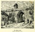
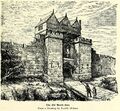
In engineering terms many of the City Gates are bridges and in general the architects who designed the gates were also known for building bridges. The Wolf Gate, situated opposite the Roman Amphitheatre, is probably built on the site of a Saxon gateway. Built in the 17th century, it was rebuilt again later in the 18th century, and is linked to the Wolf Tower, also known as Thimbleby's Tower a short distance to the North. The Newgate was built in 1937\38 and follows a Neo Gothic design. The Bridgegate was constructed in 1782, to designs by Joseph Turner. The Watergate was built in 1788 also to a design by Joseph Turner. St Martin's gate is little more than a concrete foorbridge erected in 1966 and spans the Inner Ring Road. The Northgate was built in 1810, to designs by Thomas Harrison. The Eastgate was built between 1768 and 1769, and replaced the original medieval gateway which was far too narrow for the increasing flow of traffic.
City gates as they are now:
City gates as they once were:
Useless facts about the City Gates
- Wolfgate (also known as Peppergate) is traditionally said to be the origin of the Cheshire proverb about "shutting the Peppergate after the daughter has fled".
- Bridgegate features a much damaged carving of the three feathers with a date of "171-". The missing digit is a "4", as it commemorates the installation of George Augustus as Prince of Wales.
- Watergate features a drinking fountain. Several of the city gates featured public drinking fountains sponsored by Edgar Garston. They were among the first public drinking fountains in the UK, but the only survivor is at the Watergate (and doesn't work).
- Northgate bears an inscription indicating that it replaces a Roman gateway this is not entirely accurate as the previous gate is almost certainly medieval.
- Eastgate's clock used to be wound by hand with a man being sent by train from the clockmakers to do it.
- St Martin's Gate is named after St Martin which was demolished in the construction of the Ring-Road. This new gateway through the walls was designed by the City Engineers, A H F Jiggens and noted architect George Grenfell-Baines of the Building Design Partnership, with approval from the Royal Fine Arts Commission, as was required at the time. It was opened in 1966 by the Minister of Transport, Barbara Castle. It was known for a while as "Jiggens Bridge". During construction, remains of a Roman corner tower were found, the location of which has been marked out in cobbles at the base of the concrete steps leading down from the bridge.
- Newgate was almost named the "Munich Gate" after the Munich Agreement of 1938.
Other Bridges in Chester
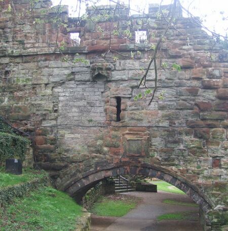
Watertower Bridge
The Watertower (originally known as the New Tower) is a 14th-century tower in Chester, Cheshire, England, which is attached by a spur wall to Bonewaldesthorne's Tower on the city walls. The tower, together with its spur wall, is recorded in the National Heritage List for England as a designated Grade I listed building. The original name of the tower was New Tower but in the 17th century it became known as the Water Tower, although the City Assembly tried to insist on the usage of its correct name. The spur wall includes a bridge which initially crossed a part of the River Dee. By the end of the 16th century the river had silted up and the tower was landlocked. A stone plaque on the north side of the arch reads
- "This Arch was Rep.[aired] / John Pemberton / Esq Mayor / Tho. [?……..] Esq / Tho. Holland / Jas Comberbache / Justices of the Peace Muringers / 1730"
As the bridge is a part of the City Walls it was the responsibility of the Murengers to maintain it.
Dingle Bridge
In October 1849, the “Civil Engineer and Architect's Journal” had reported on the construction of “Novel Suspension Bridge” at Chester. This crossed “The Dingle” between the embankment of the Grosvenor Bridge and Curzon Park where new housing was being developed by Earl Howe. The new bridge was of a unique design as it dispensed with piers and suspension rods above the level of the deck which formed the walkway. The deck of the bridge was instead supported on “chains” made-up of 15-foot long wrought-iron rods which had an eye at each end and were joined together. One end of these chains was secured to an abutment at the Grosvenor Road end, but at the Curzon Park end an extension of the the chains passed around a “strong grooved barrel” and dropped into a pit, where the chains supported a cast-iron plate loaded with a large quantity of heavy masonry. The effect of this movable weight was to keep the bridge under tension while allowing for expansion and contraction as the temperature varied. This “self-adjusting” bridge was reported far and wide, including in the American press. This innovative bridge has long since been replaced by a more conventional lattice structure.
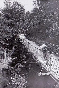
Had the Elesmere canal been completed along the route originally proposed this may well have been the valley where the canal, after crossing the Pontcysyllte Aqueduct, and passing through Wrexham, would have come down a flight of locks and joined the River Dee.
Canal Bridges
In rural sections the canal is punctuated by picturesque humped back bridges. These "passage bridges" were built in the 18th century to allow landowners to access their land either side of the new waterway and to provide passage for local traffic and farm animals. These brick bridges (such as those at Stoak) still retain some of their traditional grey paint characteristic of the Shropshire Union Canal Company. Not all the bridges take this form, for example, the "Pretty Bridge" at Caughall which has a wrought ironwork span. All the bridges along the canal have been numbered by the canal company: for example Egg Bridge is No.119 and Pretty Bridge is No.134. Canal-folk often used to refer to locations along the canal by reference to bridges as they did in the investigations into the mysterious death of Charles Moston.
City Road bridge (1863) has ironwork which was produced at the Egerton Iron and Brass Foundry, which was operated by James Mowle & Co. in 1871 and Mowle and Meacock by 1892. The foundry was located between Crewe Street and Albert Street, but had been demolished by 1910 when Egerton Street school was built on the site.
"Union Bridge" (also known as "Seller Street Bridge", was construced by Thomas Lunt (1770-1851), born in Tattenhall, who was a Quaker, and developer of Chester in the early 19th Century. Although the land between the south bank of the canal and the gardens to the north of Foregate Street was still fields in the 1770s, development started there before 1800, and Lunt built his elegant bridge to allow development to continue northwards.
Roving Bridge
Next to the Graving Dock at the boatyard is a "Roving Bridge". This allows the horses drawing a barge to cross from one side of the river to the other where the tow-path changes sides, as it does here. The clever design of the bridge allows this to happen without disconnecting the tow rope or tangling it. The bridge bears a memorial to L. T. C. Rolt who was a prolific English writer and the biographer of major civil engineering figures including Isambard Kingdom Brunel and Thomas Telford. He is also regarded as one of the pioneers of the leisure cruising industry on Britain's inland waterways, and as an enthusiast for both vintage cars and heritage railways. Next to the roving bridge is the only surviving swing bridge in Chester.
Cow Lane Bridge
The earliest illustrations of Cow Lane bridge show a stone arched structure. This may be the original bridge from the construction of the canal in the 1770's. A new bridge was constructed around 1859, originally designed for light traffic, however with the increase in traffic in the mid 20th century, it was required to be replaced with some degree of urgency. Reconstruction began in February 1959, which took around 14 months to complete. The present bridge was opened on 26th January 1960.
Other Railway Bridges
There are a host of other railway bridges around Chester, including two which form a portion of the walkway around the City Walls at the northwestern corner. The most familiar to many Cestrians is the Hoole Railway Bridge which dates from 1890. The bridge has often been the subject of debate with a noted petition being organised in favour of a Hoole Railway Footbridge in 1889. As noted on the Hoole Historical and heritage society website:
- "In the 1870s the Hoole Local Board complained about its state and how the railway’s vehicles queuing at its weighbridge impeded the flow of traffic. In 1902 a conference at Chester Town Hall called for it to be widened, “on cattle market days it was impossible for pedestrians”. A scheme was proposed for a carriageway at least 30 feet wide plus 10 feet wide pavements; this was ruled out and in 1905 an amended scheme costing £15,500 was agreed, the costs to be shared between Chester, the County Council, Hoole Urban District and Newton Parish Councils; this would see the construction of a footbridge alongside the existing structure. 112 years later, we are still waiting."
The site of the Hoole Railway Bridge was previously occupied by Flookersbrook bridge, which crossed the stream of the same name.
There is an interesting railway footbridge on Hoole lane. This is a 63 metre tubular truss bridge with a structure that is a variant on the Warren Truss, a weight-saving design based upon equilateral triangles. The bridge was manufactured to a standard design by "Tubewrights" and no doubt shipped in part form before being erected at this site in 1961. Tubewrights were based in Newport in South Wales and closed in 1981 although many of their bridges still remain in use across the UK. They had a factory in Liverpool. The Warren Truss is named after the British engineer James Warren, who patented it in 1846. The bridges around the Leadworks were one reason for its closure as they limited the weight of goods which could be transported over them.
Lifting Bridge
The canal at Chester has a branch leading to the tidal part of the River Dee via the Dee Basin. This was once crossed by a swing-bridge which has now been made fixed. The bridge crosses the river lock, which is not operational and does not permit passage. Passage to the river would in any event be a complex procedure, as the now-fixed swing-bridge provides very little headroom and can only be passed at low tide. However an exit from the river lock to the Dee would only be possible at high tide, requiring a wait of some hours in the river lock. The branch to the river is also crossed by a modern lifting footbridge (the only one of it's type in Chester). This was constructed in 1998.
Bridge of Sighs
Alongside the canal bridge at Northgate is a narrow stone arch which spans the chasm containing the canal. This is known as the "Bridge of Sighs". It is best seen from the bridge crossing the canal outside the Northgate or from the tow-path below. This is a flimsy-looking structure with no railings, and there is no means of accessing it at either end.
The bridge cost £20 ($30) to build in 1793, and was designed by Joeseph Turner. It originally went from the Prison to a nearby chapel (in St John's Hospital) and had over-arching iron railings to prevent the prisoners from escaping (these were removed in WW2). It is described by Ronald Leigh in his memories recorded at the The Museum of Policing in Cheshire as follows:
- Prisons unfortunately always seem to be necessary in any form of communal life and Chester seems to be no exception. No doubt the Romans had one but this is no longer apparent. However the site at the one at the Northgate is still on record. It forms part of the actual Northgate and the dungeons were in the sandstone rock of its foundations. The place of execution was also in the jail itself and prisoners before their execution were taken outside the walls to the church of Little St. John, which stood on or near the present site of the Blue Coat building. It was found that whilst taking this last walk, friends of such prisoners frequently staged attempts to free them. In order to foil such attempts by these footpads thieves and felons, the authorities in 1793 built the small bridge which can still be seen, less its protecting railway between the City walls in the west side of Northgate over the moat/canal to the Blue Coat school.
There is an error in this account as there was in fact an earlier bridge which served the same purpose. This is mentioned in the 1777 report on the prison by John Howard who makes it clear that such a bridge was already in use by those who were not about to be executed:
- "MR DUKE is Chaplain to the Blue Coat School and officiates in little St John's Chapel belonging to the School. A Navigation parts that from the Prison yard and a foot bridge made for the purpose gives these Prisoners an opportunity of attending Divine Service when it is performed, that is Prayers twice a week and Sermon once a month. Few Prisoners in City or Town Gaols have such a privilege."
The name of the present bridge is said to be taken from the same-named bridge in Venice which passes over the Rio di Palazzo, and connects the New Prison (Prigioni Nuove) to the interrogation rooms in the Doge's Palace. The one in Venice dates from 1600. The Venetian bridge's English name was supposedly bestowed by Lord Byron (22 January 1788 – 19 April 1824) in the 19th century as a translation from the Italian "Ponte dei sospiri", from the suggestion that prisoners would sigh at their final view of beautiful Venice through the window before being taken down to their cells. As the Chester bridge was built in 1793, when Byron was very young it must have taken the name sometime later.
Stone Bridge
Flookersbrook marks a large part of the ancient bountary of Chester, and one part of its course is now known as Finchett's Gutter. The course of the gutter seems to have been modified in places as the "Stone Bridge" which crossed it would now be located on the corner of the small park on Cheyney Road. Indeed the stonework on either side of the turn in Cheyney Road is believed to be a remnant of the bridge. The earliest reference to a bridge at this location is between 1220-1250 when it was known as Wyardesbrugge, a name that is partly Old English in origin and this might suggest a bridge was there much earlier in the medieval period.
Aldford Iron Bridge
Aldford Iron Bridge is a bridge crossing the River Dee north of the village of Aldford, Cheshire, England, linking the village with Eaton Hall, forming part of the Buerton Approach to the hall. The bridge was designed by Thomas Telford and built by William Hazledine for the 1st Marquis of Westminster and was completed in 1824. It is built in cast iron and has yellow sandstone abutments forming a single arch measuring 50 metres. It has cast iron railings and double gates at the crown of the bridge. The bridge now provides a crossing over the river for the long-distance footpath of the Marches Way. Hazledine was an English ironmaster. Establishing large foundries, he was a pioneer in casting structural ironwork, most notably for canal aqueducts and early suspension bridges. Many of these projects were collaborations with Thomas Telford, including the Pontcysyllte Aqueduct and the Menai Suspension Bridge.
A gallery of "other bridges"
Lunt's "Union Bridge" over the canal;
A relic of Mowle & Co., on the canal bridge on City Road;
The "Dutch" lifting bridge, Watertower and "Ark"
Other Bridges near Chester

Pontcysyllte Aqueduct
Pontcysyllte Aqueduct, Thomas Telford’s "Stream in the Sky", has been awarded World Heritage status. This cast iron trough, balanced on giant stone pillars 127ft above the River Dee, has been transporting narrowboats across the 7ft 2in wide aqueduct since 1805. It is the longest aqueduct in Great Britain and the highest canal aqueduct in the world. The aqueduct was to have been a key part of the central section of the proposed Ellesmere Canal, an industrial waterway that would have created a commercial link between the River Severn at Shrewsbury and, via Chester, the Port of Liverpool on the River Mersey. Although a less expensive construction course was surveyed further to the east, the westerly high-ground route across the Vale of Llangollen was preferred because it would have taken the canal through the mineral-rich coalfields of North East Wales. Only parts of the canal route were completed because the expected revenues required to complete the entire project were never generated. The mortar used lime, water and ox blood. Blood and extracts of blood containing haemoglobin have been used in the construction and building industry since antiquity as air entraining colloids to inexpensively strengthen mortar exposed to freeze-thaw temperature cycles.
Somewhat hilariously, the book "Chronicle of Chester" claimed that the Chronicle's editor John Fletcher designed the bridge. This is completely untrue although Telford was assisted in his surveying by another John Fletcher.
Dutton Horse Bridge
Dutton Horse Bridge is a timber twin-span footbridge across part of the Weaver navigation, near the villages of Acton Bridge and Dutton in Cheshire, England. The bridge is located at SJ 583 767, between the Dutton Locks and Dutton Viaduct. It carries the towpath across a subsidiary channel used to regulate the water level, at the point where it rejoins the main river. The bridge dates from 1915–1919 and is by John Arthur Saner. It is recorded in the National Heritage List for England as a designated Grade II listed building; the listing describes it as "an elegant structure in the functional waterways tradition". The bridge is one of the earliest remaining examples of a laminated timber structure, and is also believed to be the sole laminated greenheart timber bridge in the country.
The nearby Acton swing bridge is 83.5 m long and 8 m high bowstring truss balanced swing bridge, based on an 1893 design also by John Arthur Saner.
Sources and Links
Related Pages
- City Gates;
- Roman Chester;
- Old Dee Bridge: more detail on the bridge;
- Grosvenor Bridge: more detail on the bridge;
- Suspension Bridge: more detail on the bridge;
- Canalside;
- River Dee Drone Footage:
Online
- Hockenhull Bridges;
- Dee Bridge Disaster: on Wikipedia;
- Grosvenor Bridge: on Wikipedia;
- Old Dee Bridge: on Wikipedia;
- Old Dee Bridge: at Gatehouse;
- "The Old Dee Bridge at Chester";
- Bridges in Cheshire; on Wikipedia;
- Bridges in Cheshire West and Chester: photo gallery from Wikipedia;


